
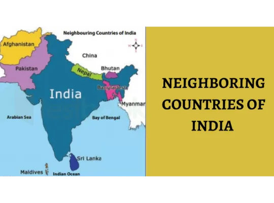
 This article will explore the nations that have territorial boundaries in common with India, whether it’s through a land or sea border. India shares its borders with a total of nine countries, with two having maritime borders and the remaining seven sharing land borders.
India is situated in the southern region of Asia, boasting a land boundary stretching 15,106.7 km and a coastline spanning 7,516.6 km. Geographically, it falls within the Northern Hemisphere latitudinally and the Eastern Hemisphere longitudinally.
Regarding population, India ranks as the second most populous nation globally. In terms of land area, it stands as the seventh largest country worldwide.
Check below is a table that showcases a brief description of India and its neighbouring countries:
| Country | India |
| Number of Neighbouring Countries | 9 |
| Length of Land Border | 15,106.7 km |
| Coastline | 7,516.6 km |
India’s Neighbouring Countries – Capital & State Borders
Below is a table containing information about the neighboring countries of India, including their capitals, and the Indian states that share borders with them:
The following table presents details about India’s neighboring nations, comprising their capitals, as well as the Indian states that have shared borders with them.
| Neighbouring Country | Capital | Indian State/UTs sharing Border |
| Afghanistan | Kabul | Ladakh (PoK) |
| Bangladesh | Dhaka | West Bengal, Meghalaya, Mizoram, Tripura, Assam |
| Bhutan | Thimphu | West Bengal, Sikkim, Arunachal Pradesh, Assam |
| China | Beijing | Ladakh, Himachal Pradesh, Uttarakhand, Sikkim, Arunachal Pradesh |
| Myanmar | Yangon | Arunachal Pradesh, Nagaland, Mizoram, Manipur |
| Nepal | Kathmandu | Bihar, Uttarakhand, UP, Sikkim, West Bengal |
| Pakistan | Islamabad | Jammu and Kashmir, Ladakh, Punjab, Rajasthan, Gujarat |
| Sri Lanka | Sri Jayawardenepura Kotte (Legislative Capital), Columbo (Executive Capital) | Separated from India by the Gulf of Mannar |
| Maldives | Male | Lies in the south-west part of Indian Ocean below the Lakshadweep Islands |
Click to View MEA (Ministry of External Affairs), Government of India.
Neighbouring Countries Details in Short
Next, we will explore the nations that border India, providing crucial details relevant to competitive examinations.
Afghanistan:
- Border Length: 106 km
- Official Languages: Dari, Pashto
- Currency: Afghan Afghani
- States/ Provinces: 34 Provinces
- Located in Central Asia, Afghanistan covers an area of approximately 652,230 sq km. Its economy primarily relies on agriculture. The prevalent religion is Islam, and key industrial activities include the production of cotton textiles, woven carpets, handicrafts, and woollens.
Bangladesh:
- Border Line: 4096.7 Km
- Official Language: Bengali
- Currency: Bangladeshi Taka
- States/ Provinces: 8 Provinces
- India shares one of the world’s longest borders with Bangladesh, spanning an area of 143,998 sq km with a coastline of 580 km. The Bangladeshi states of Raj Shahi, Dhaka, Chittagong, Khulna, Rangpur, and Sylhet border India.
Bhutan:
- Border Line: 699 km
- Official Language: Dzongkha
- Currency: Bhutanese Ngultrum
- States/ Provinces: 20 States
- Covering an area of 38,394 sq km, Bhutan’s population predominantly practices Buddhism followed by Hinduism. The country follows a parliamentary form of Government, with its economy relying on hydropower, agriculture, forestry, and tourism.
China:
- Border Line: 3488 km
- Official Language: Mandarin
- Currency: Chinese Yuan
- States/ Provinces: 26 Provinces
- China, the world’s most populous country, spans an area of about 9,596,960 sq km. It boasts one of the world’s fastest-growing economies. While India and China maintain amicable relations, there are occasional disputes that strain their ties.
Myanmar:
- Border Line: 1643 km
- Official Language: Burmese
- Currency: Burmese Kyat
- Located in western mainland South Asia, Myanmar covers an area of 676,578 sq km. The country operates under a presidential republic with a bicameral legislature. India is Myanmar’s fourth-largest export market.
Nepal:
- Border Line: 1751 km
- Official Language: Nepali
- Currency: Nepalese Rupee
- States/ Provinces: 7 Provinces
- Nepal is situated to the northeast of India, spanning an area of 147,181 sq km. The world’s tallest peak, Mount Everest, lies in Nepal. Moreover, eight of the world’s ten tallest mountain peaks are located there. Tourism plays a major role in the economy, and the Government operates as a federal parliamentary republic.
Pakistan:
- Border Line: 3323 km
- Official Language: Urdu
- Currency: Pakistani Rupee
- States/ Provinces: 4 Provinces
- Initially a part of India, Pakistan became a separate nation covering an area of 796,095 sq km. The country follows a federal parliamentary system, with the Prime Minister as the head making significant decisions.
Sri Lanka:
- Border Line: Sea Border
- Official Languages: Sinhala, Tamil
- Currency: Sri Lankan Rupee
- States/ Provinces: 9 States
- Sri Lanka, one of the two countries sharing the Indian coastline, spans an area of 65,610 sq km. It is a popular tourist destination and boasts diverse ethnic groups and religious cultures.
Maldives:
- Border Line: Sea Border
- Official Language: Dhivehi
- Currency: Maldivian Rufiyaa
- States/ Provinces: 1 Only
- Positioned in the Indian Ocean-Arabian Sea region, the island nation of Maldives is situated to the southwest of India. Encompassing an area of just 298 sq km, Maldives comprises over a thousand coral islands. The prevailing religion in the country is Islam.
Conclusion
In conclusion, the neighboring countries of India form a diverse tapestry of cultures, languages, and geographical landscapes. These nations share historical ties, trade relations, and, at times, face geopolitical challenges. Understanding and appreciating these neighboring countries is essential for fostering regional cooperation and global stability.
FAQs
Q1: How many neighboring countries does India have?
A1: India shares its borders with a total of nine countries, including Afghanistan, Bangladesh, Bhutan, China, Maldives, Myanmar, Nepal, Pakistan, and Sri Lanka.
Q2: Which Indian state does not share a border with Bhutan?
A2: Meghalaya is the Indian state that does not share a border with Bhutan.
Q3: Which two countries share the longest border in the world with India?
A3: India shares the longest border in the world with Bangladesh.
Q4: How many countries share a sea border with India?
A4: Seven countries share a sea border with India.
Q5: Which neighboring country of India has the smallest land border with India?
A5: Afghanistan shares the smallest land border with India.
Q6: Where is India located geographically?
A6: India is located in the southern part of Asia, with a land border of 15,106.7 km and a coastline of 7,516.6 km. It is situated in the Northern Hemisphere latitudinally and in the Eastern hemisphere longitudinally.
Q7: Which neighboring country of India is the smallest in terms of area?
A7: Bhutan is the smallest neighboring country of India in terms of area.
These FAQs provide information about India’s neighboring countries, their borders, and geographical location.